


Kongsberg Geospatial Advances Solutions for Airspace Monitoring and Managing Unmanned Traffic
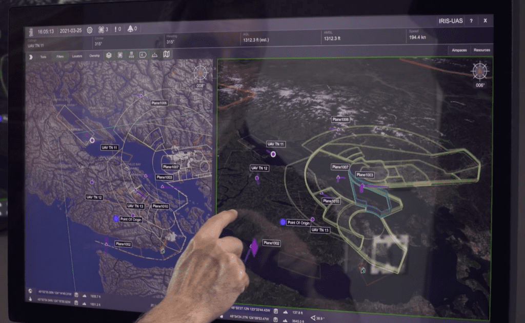
The IRIS UxS platform enables an operator to manage one or more unmanned aircraft flying BVLOS operations. (Photo: Kongsberg Geospatial)
Kongsberg Geospatial, based in Canada, develops software for geospatial visualization and situational awareness that is used for air traffic control and air defense applications. One of Kongsberg’s products is IRIS UxS, an airspace visualization system for operators conducting unmanned aircraft beyond a visual line of sight (BVLOS). The company also offers IRIS AM, a real-time airspace management system that was designed to facilitate the safe integration of unmanned systems.
The IRIS software platform is essentially the user interface built on top of Kongsberg’s TerraLens, a geospatial SDK that provides real-time 2D and 3D mapping, according to Paige Cutland, VP of Sales and Marketing. TerraLens is optimized for mission-critical, real-time applications like air traffic control.
During a webinar hosted by the Association for Uncrewed Vehicle Systems International (AUVSI) this week, Cutland explained how unmanned aircraft operators use the IRIS platform for monitoring BVLOS operations at remote operations centers, and he shared some of the recent projects the team has worked on.
One of the new features that will be released soon for IRIS is a sensor correlator function. “We’re doing our first trials onsite with live sensors next week, providing a correlator for Echodyne’s EchoGuard radars,” Cutland said. “They have four different radars and don’t want to see duplication as it goes from one radar coverage area to overlapping coverage area in another.”
Kongsberg Geospatial also provided a similar multisensor correlator for the sensors in Iris Automation’s Casia G ground-based surveillance system. With the IRIS solution, operators will have a simplified view of the data even when sensor coverage overlaps.
Another of the company’s customers is funding development of a suggested avoidance visualization feature for IRIS. “This builds on our conflict prediction service,” Cutland explained. “It provides visualization to the operator for the suggested avoidance maneuver they should take, which will greatly improve their ability to make decisions very rapidly based on a variety of constraints and data they’ve entered.”
The next step, which he says will be coming soon, is to take the human out of the loop and to direct automated avoidance maneuvers straight to the autopilot.
Kongsberg’s team has also recently integrated with FlytBase, an enterprise drone automation platform, to develop a tool for controlling vehicles through the cloud.
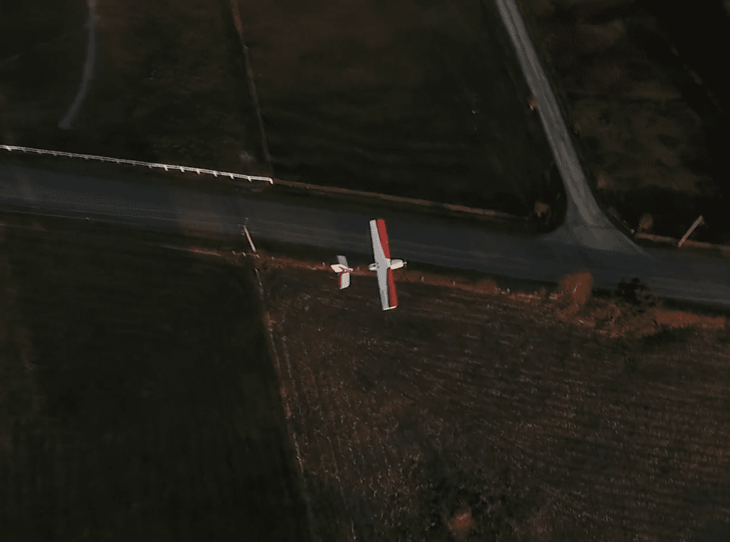
The IRIS platform can be used for managing a variety of autonomous aircraft, from small drones to unmanned VTOL aircraft. (Photo: Kongsberg Geospatial)
The main function of IRIS, Cutland explained, is to combine all sensor and data feeds into a single picture that allows the operator to monitor the airspace and to deal with situations as they arise. This prevents any of the problems that come along with adding a new data feed.
The IRIS platform aggregates available information “to allow for flexible presentation of different data feeds containing information from the airspace: terrain information, satellite imagery, periodic aeronautic data, live data, ADS-B, traffic feeds, etc.,” said Cutland.
He added that Kongsberg Geospatial can integrate numerous types of data feeds into the IRIS remote operations software, including LiDAR, RF detection, UTM feeds, ATC feeds, and EO camera/video.
The IRIS platform could be particularly useful for last-mile drone delivery companies to enable a single operator to control multiple drones at once. With a fleet of autonomous drones, the operator simply monitors what the aircraft are doing, and IRIS allows the operator to be in the loop for certain aspects of the mission or for any contingencies that arise along the drone’s route.
One company offering drone delivery services, Skyports, partnered with Kongsberg Geospatial last year to enable BVLOS operations during a three-month-long medical drone delivery project in Scotland. The partners were able to conduct 14,000 kilometers of BVLOS drone flights carrying COVID-19 test samples and kits, medicine, and PPE during the project.
The Canadian Coast Guard uses Kongsberg Geospatial’s IRIS UxS software to safely pilot the Shield AI V-BAT aircraft, a long-endurance, unmanned vertical take-off and landing (VTOL) surveillance system, for offshore sea trials. Kongsberg’s Modular ISR Data Analysis and Storage system (MIDAS) takes in data feeds from the cameras and sensors onboard the VTOL aircraft. The IRIS software displays information from the data feeds and provides a comprehensive situational awareness picture of the airspace.
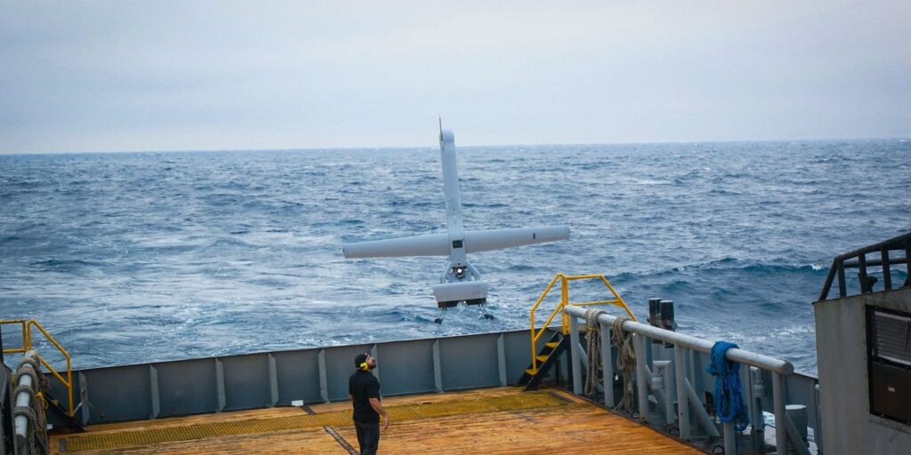
Pictured above is the Shield AI V-Bat aircraft, used by the Canadian Coast Guard to conduct offshore sea trials. (Photo: Kongsberg Geospatial)
The post Kongsberg Geospatial Advances Solutions for Airspace Monitoring and Managing Unmanned Traffic appeared first on Avionics International.
—————
Boost Internet Speed–
Free Business Hosting–
Free Email Account–
Dropcatch–
Free Secure Email–
Secure Email–
Cheap VOIP Calls–
Free Hosting–
Boost Inflight Wifi–
Premium Domains–
Free Domains